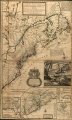
Karte von 1715 "A new and exact map of the dominions of the King of Great Britain on ye continent of North America, containing Newfoundland, New Scotland, New England, New York, New Jersey, Pensilvania, Maryland, Virginia and Carolina."
Stich vom Hermann Moll
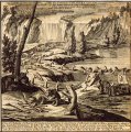
Die als "Beaver Map" bekannt gewordene Darstellung zeigt eine Gruppe von Bibern vor den Niagarafällen, die den Dammbau hochgradig arbeitsteilig organisieren. Es gibt unter anderem einen Dammbaumeister, der die Arbeit inspiziert und einen Aufseher, der kontrolliert ob bei der Arbeit verletzte Biber tatsächlich arbeitsunfähig sind.
Die Bildunterschrift:
“A View of ye Industry of ye beavers of Canada in making Dams to stop ye Course of a Rivulet, in order to form a great Lake, about wch they build their Habitations. To Effect this: they fell large Trees with their Teeth, in such a manner as to make them come Cross ye Rivulet, to lay ye foundation of ye Dam; they make Mortar, work up, and finish ye whole with great order and wonderfull Dexterity. The Beavers have two Doors to their Lodges, one to the Water and the other to the Land side. According to ye French Accounts.”